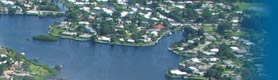
Palma Sola Bay
Palma Sola Bay and its watershed have seen many changes since the mid-1880s. A pre-development landscape of pine forests, mangrove and salt marsh flats, herbaceous wetlands, and creek sloughs was supplanted over time by agriculture followed by urban development and supporting infrastructure, including the construction of drainage canals. Untreated stormwater was routed to the bay. Major historical impacts to Palma Sola Bay occurred in 1910-12 with the creation of the Cedar Hammock drainage project, and in the 1950s and 1960s with the construction of the Manatee Avenue causeway across the bay and mosquito ditching in the tidal wetlands. Boat channels were dredged and spoil was deposited on intertidal wetlands. Urban growth and its attendant environmental consequences over the past 60 years have substantially impacted the watershed and current and proposed land development policies threaten its future ecological integrity.
Land preservation through public purchasing programs is an important tool to reestablish ecosystem services in the area. Major restoration work has been undertaken in large preserves, including Perico, Neal, and Robinson Preserves.
Palma Sola Bay is highly valued for recreation and habitats that support fish and wildlife.
Roundtable Panel Discussion
Moderator:
- Nick Baden, Manatee County Historical Commission
Panelists:
- Barry Wharton, HDR-EOC
- Charlie Hunsicker, Manatee County Natural Resources
- Kathe Fannon, Captain Kathe Boat Tours
- History of land use changes in Palma Sola Bay Watershed
- Habitats, water quality and circulation in Palma Sola Bay
- Recreational use of Palma Sola Bay
- Policy challenges for Palma Sola Bay
- Vision for restoration and for a healthier Palma Sola Bay
- Envisioning a healthy future for Palma Sola Bay – next steps
- Innovative decentralized strategies for stormwater management for Palma Sola
- Growth Planning, Density, and Jurisdictional Control - Sarasota Bay and Palma Sola Bay Coastal High Hazard Areas